Sunday, 19 September 2021

Ambapani Water fall | Teetir Dhod ( Local name ) Village aamoniya, Tal Dolvan Dist Tapi

Route : Surat - Kadodra - Palsana - Bardoli - Vyra - Turn Roght toward bhenskatri - Tichakiya - karanjvel - before chakdhara checkpost turn right side toward padamdungri road - dhamandevi - after cross river bridge - A entry is 1 km before amaniya village
Date of journey 19/09/2021  Distance is 105 km from surat

It's called "Teetir Ghat" by locals.The place is very beautiful and peaceful. Here you can enjoy your trip with friends and family.
Remember : The waterfall's water available till October month only.

Entry Point where trek start for teetir dhodh
location : https://goo.gl/maps/RD4HCeDVFFi7p5yR8

Total 2.6 km distance from Starting point, you can park your vehicle on road.
Hire guide from Aamoniya village or ambapani camp site.
although it is flat pagdandi, u can direct reach to waterfall by follow pagdandi path, but hire guide thats why local people earn some money.
this treak is flat, no upside hiking so children can easily walk age above 5yrs & enjoy the trail.

Exit Point for access water fall & bath upperside of river
Location : https://goo.gl/maps/dXntZEgjHpNCTVky8


One Request : don't throw garbage here so we can preserve for our next generation.
near place for visit is aamoniya / amabapani camp site. 2 km far from this place


Watch video to get highlights of Trek


video of Trek route 


Aamaniya eco-tourism ( Ambapani ) A place for nature lover

Route : Surat - Kadodra - Palsana - Bardoli - Vyra - Turn Roght toward bhenskatri - Tichakiya - karanjvel - before chakdhara checkpost turn right side toward padamdungri road - dhamandevi - after cross river bridge - amaniya village then turn left toward amaniya camp site.
Date of journey 19/09/2021

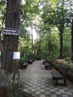
Amaniya Eco Camp site is developed by Government of Gujrat tourism department. Big space with good parking facilities.
car charge 30/- per person entry fees 25/-
Time morning 8 am to 6 pm
Eco Camp site have small canteen,
For Night stay 4 tree house,
For Food Area one big gazebo for eat food,
Small children play area, 
Boating also available but now a days it not run.

Canteen is run by local village Pragati sakhi mahila mandal, you can order food like bhajiya, tea , coffee, pauva, also lunch like dal rice chapati, sabji.
if you are nature lover, and spend time with family & friends for relaxation you can enjoy the place.
it is half day or full day spot.
Night stay charge 2000 for tree house.
nearer Teetir Dhodh also called as amabapani dhodh, you can enjoy this fall in monsoon only
for booking & information U get picture as last in blog


Sunday, 29 August 2021

Pandar Dhod ( Raja Rani Waterfall ) : lesser known place in Purna Wildlife Sanctury

Raja Rani waterfall name from 2 water fall near arond, it called raja rani, also called as pandar dhod
Date : 29 /8/2021
Route : Surat- NH 8 - Kadodra- Palsana - Bardoli - Vyra - Trun right side toward bhenskatri-mahal road- turn left from dolra- jhankhri - dholia - Kosimda village - Ask local or follow google map till dead end.
Another route from Dardi village in their no much hiking

we started our journey from 6.30am from utran, we are 5 doctor friends. Dr Nitin kanani ( CEO Vahcare Healthcare ) Dr Manoj Savani  ( Savin Skin Care ) Dr Kashypa Choudhry ( Dentist ) Dr jaydev Dhameliya ( Candor IVF & radha Hospital ) Dr Bharat Savani ( shyamosa Skin Care ). we take first half at duliya chokdi near bardoli for tea break. 
next move towward madhi khami for breakfast, we eat delicious khamni with petis. afterword reach vyara & the start google map, follow google map & local support reach at base point where fall started. 
ask local guy support from retired  school teacher who leave near starting point. he manage local guide name gomabhai. he came with us & guide us route. it take 1 hrs to reach top of the fall. 3km distance need high endurance for reach their. after relaxing top again descend as base of fall. too risky trek downside. 
Avoid children this trek. at downside big rocks with too much lil at their make more sleepery. we remove our shoes & shock & reach base of fall with bare foot. amazing experience at down side of fall. take few pics & then came again top of fall.


Sunday, 15 August 2021

Ankda waterfall, Near Vangan ( Vansda) Natural Beauty of Dang

Ankda waterfall is one of the top and best destinations for family and friends If you like Greenery & waterfall. Ankda waterfall also known as Vangan Waterfall in google map.

Route: Surat- NH 8- Palsana - Bardoli - Mahuva - Unai - Vansda- toward saputara road - mahuvas- Turn right side Navtad- Ambapani - Vangan|
Date : 15 Aug 2021

People of Vangan Village is cooperative & Helpful. Unseen natural beauty is in vangan. If you are trek lover, you have good news their is vangan hill, which you can do by trekking & reach top of hill. need support of local guy.
Water fall is three step & height is around 100-150 feets with sub branches at downside. from top main strem fall afterwrds it down in small multiple branch & people can enjoy bathing under fall. It is best place for natural photography. Once you reach vangan village, car is drive through 1km & Then You have to park car, local village people charge 50/- per car. then u asend more 1 and half km to reach fall.
you can get home made food also, u can order local villager & food conatin roti, sabji, dal rice. if u bring your own home food they provide space for sitting if outside is raining. people of vangan is supportive.


Thursday, 15 July 2021

Places Visit In & around Dang ( On way between Surat to Saputara)

સુરત થી સાપુતારા કે આહવા બાજુ જતા રસ્તામાં ફરવા લાયક સ્થળો...ના ગુગલ મેપ , પ્રાકૃતિક જગ્યાઓ , ધોધ, ઝરણાં, જંગલો, મંદિરો,વગેરે.🌳🌴🌿🌱🏞️🌊🏔️


જાનકી વન.
https://maps.app.goo.gl/PW9JZcUFifkhVGb49

https://movewithoutmap.blogspot.com/2015/09/janki-van-at-bhinar-in-vasda-taluka-of.html


દંડકવન આશ્રમ વાંસદા
Dandakvan Ashram, Vihangam Yoga

https://maps.app.goo.gl/Epbyik6DmbY7TS2PA


વાંગણ ધોધ.
https://maps.app.goo.gl/m8rWLuwmviTH4eWbA
https://movewithoutmap.blogspot.com/2021/08/ankda-waterfall-near-vangan-vansda.html


બિલપુડી માવલી માતા વોટરફોલ


ગણેશ ધોધ 

Kilad ઇકો ટુરિઝમ
Kilad Eco Tourism, Navsari, Gujarat 396445. 098245 11561
https://maps.app.goo.gl/TGAr3PcQNk7ftg296

https://movewithoutmap.blogspot.com/2021/06/kilad-eco-camp-site-near-waghai-vansda.html


વઘઈ બોટનિકલ ગાર્ડન
https://g.co/kgs/7TUoeq


વઘઈ ગીરા ધોધ
https://maps.app.goo.gl/L1HY3yXTZMPQYjxp9


તેજસ્વિની સંસ્કૃતિ ધામ વાશુણા.
https://goo.gl/maps/NGx5dxoaWVDnkHtX7


કદમ ડુંગર
https://goo.gl/maps/zfjAFtH2YnGKJNoU9


બરડા વોટરફોલ ( ચનખલ પાસે )
https://goo.gl/maps/SsgsPAyi7yC8rrwm6

https://movewithoutmap.blogspot.com/2018/09/bardawaterfall-hidden-beauty-of-nature.html


પાંડવા ગુફા.
https://maps.app.goo.gl/RoA77pkDDXahS8bj7


અંજની કુંડ વોટરફોલ
https://maps.app.goo.gl/4PzgRG8e6BuyKjC26


શિવઘાટ મંદિર અને વેટરફોલ
https://maps.app.goo.gl/BaYiLv8UgrhXRkvCA

પદમ ડુંગરી
https://goo.gl/maps/FdVtUhWs91c9rfuEA

https://movewithoutmap.blogspot.com/2015/08/padamdungari-eco-campsite.html


અજમલ ગઢ..વાંસદા નજીક
https://maps.app.goo.gl/TckpZQmgA73mjjk56


વિલ્સન હિલ... ધરમપુર થી 25કિમી આસપાસ
https://maps.app.goo.gl/7zhYgLwbGCpxZutG6


સબરી ધામ .... આહવા થી નવાપુર રોડ
https://maps.app.goo.gl/G9XYdLABzxFFKCyk6


કુંડા રિસોર્ટ.
વઘઈ થી સાપુતારા જતાં રસ્તામાં સૂર્ગણા બાજુ.
https://maps.app.goo.gl/mrrscfHgyR8D3ybd9


કોશમાલ વેલી વોટરફોલ વઘઇ તો કાલીબેલ રોડ પર
https://goo.gl/maps/NGx5dxoaWVDnkHtX7

https://movewithoutmap.blogspot.com/2020/09/dsc-waterfall-hidden-gems-of-kosmal.html


📜 આ સુંદર અને પ્રાકૃતિક જગ્યા ઓ પર ગંદકી કરવી નહી (સ્વચ્છતા નું ધ્યાન રાખવું).♻️🗑️

Disclaimer: Kindly visit all places with your own Risk, Number mention for perticular location is taken from internet, may be changed.